Songan Sunrise
Situation: in the hotel, floor of Batur crater.
Just arrived.
I'd been studying up about this place.
According to the Good Book,
there's this constant problem with locals claiming to be guides, guiding you to the top.
You can pretty much just find the trail yourself and take it to the top.
But if you're a naive european tourist, you've spent just a few days here,
maybe it's easy to be duped and go and spend sixty thousand on a "guide".
Especially when they are hounding you so much.
So I sit down to have a beer and this guide sits down and is making
his pitch.
No.
Blah blah blah.
No. I just want him to leave.
Then this woman comes up to me, some caucasian tourist.
She asks me, what do you think is a reasonable price for a guide?
This one guy wanted 80,000 rups, isn't that too much?
I was astounded. Haven't you done your homework?
But there was a "guide" sitting right there.
Didn't want to really be an obvious heel.
So I just sortof alluded to the reality.
I'm talking with her and her friend,
and a few guides who are scattered about trying to secure an arrangement.
How can I talk to them without the locals (guide wanabes) understanding?
I guess they are Dutch,
so I start rattling off a few German words.
It's the only thing I could think of.
I'm really pathetic at German but at least I can say some numbers and this "guide" person can't understand.
So we're talking, and somehow I hear the other woman speaking German numbers,
like she's teaching the guide German.
Hey, you're all giving it away!
Don't you GET IT I thought.
She didn't understand anything of what I was talking about.
Or thinking.
Completely clueless.
Later on some of their friends, these three guys, show up.
They'd been up the mountain, no you don't need a guide, it's pretty easy.
The idea, by the book,
you see, was to wake up at 4am, climb the mountain with your guide,
about an hour or two, and see the sunrise.
After studying the book, I decided against doing this even without a guide.
You know they give you little hints in the book;
they said that it gets "pretty crowded" at the
top in the morning.
Too many tourists all doing the same thing.
That's the clue I needed to know enough to change my plans.
 I read more and found something about a trail to the top of the rim,
in the back, far back side of the crater rim,
starting from a little town named Songan.
Hey, this is a big crater, there's a number of towns in it.
You drive to Songan,
park your car in the temple parking lot and the trail is like 15 minutes to the top.
(Top of the rim, not Batur itself.
In other words, Songan to Blandingan, but not all the way.)
I decided to do that for sunrise the next morning.
I read more and found something about a trail to the top of the rim,
in the back, far back side of the crater rim,
starting from a little town named Songan.
Hey, this is a big crater, there's a number of towns in it.
You drive to Songan,
park your car in the temple parking lot and the trail is like 15 minutes to the top.
(Top of the rim, not Batur itself.
In other words, Songan to Blandingan, but not all the way.)
I decided to do that for sunrise the next morning.
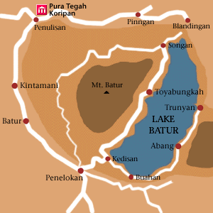
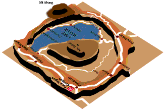
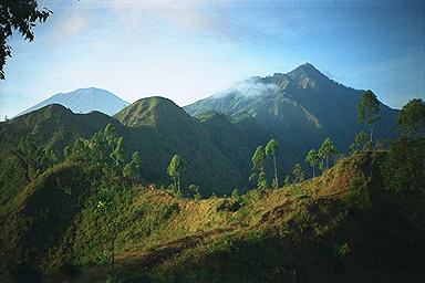
It's really hard to see from a flat map, but Mt Batur in the center is a mountain, raised up.
But also, there's a crater ridge all around the outside, like a doughnut-shaped mountain.
The road on the map from Penelokan around to Pinngan runs
along the top of the ridge, the ridge continues around,
includes Mt Abang (dark area close to the town Abang on map)
and encloses all of Lake Batur.
So, it's deceptive, but Penelokan and Kedisan look close together
on the map but it's a rough ride downhill.
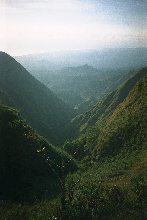
It's also hard to see from these pictures because it's so BIG,
it's even hard to understand it while you're looking at it.
Too many clouds to see the opposite side of the rim, and it's jagged anyway.
Geologically, Batur was a huge volcano.
It blew its top, leaving just the ridge.
(This was like millions of years ago.)
Then, it started building up again, resulting in the Mt Batur you see in
the middle of the crater.
There's a geological theory called the "hot spot" theory,
that says that there's hot spots under the crust where lava wells up,
and fights its way to the surface, making a volcano.
As the continental plates grind along, over century after century,
the point on the crust under the hotspot moves,
resulting in a straight sequence of volcanos.
Hawaii is such a sequence, and the most recent are on the island of Hawaii.
And if you climb to the top of any of these mountains here, you can see that
Batur, Abang and Agung all line up perfectly.
Pretty neat!
(OK mister geology scientist know-it-all,
how can several of them be active at the same time?
I dunno.
Maybe it's like you can't teach an old volcano new tricks.)
The evening in that hotel was completely dead.
You'd think with that number of tourists there would be some partying...
I guess everyone is getting up early.
At about 4am there was commotion outside.
The guide people leaving.
I went back to sleep for an hour.
Then I got up and got into the car.
My pack was packed, I was all ready to go.
As I was driving out of the hotel parking lot,
some guides were flagging me down, asking if I needed a guide.
I drove by.
It was still dark. The road is rough, it's over a lavafield after all,
and you can't take it quickly.
Behind me was a motorcycle. I feared it was a guide who wouldn't quit.
After a few minutes, he passed me, and I relaxed. Then I realized why he
passed me. We were coming up on the first trailhead (there's trailheads up the
mountain all along the inner road, approaching from all sides.
This is a BIG crater, I told you.)
As I passed the trailhead and its sign, there he was, standing proudly,
directing me, here it is!
I drove past.
After a minute or two, I saw the headlight again in my rear view mirror.
This was repeated at the next trailhead.
I learned to ignore him.
If he never does anything that you accept, you don't owe him anything.
I drove into the village of Songan. We came to a T intersection.
Left or right? It was still dark, the only person
around was the guide. I asked him the way to the temple,
he misunderstood and directed me Left.
I drove for a while and realized I was going further away
from the lake and I turned around,
a U turn.
At that point I think I lost him.
Of course he was directing me to the next trailhead, not to the temple.
 The town of songan is simple; it's a T intersection. You take the other road and it ends at the temple.
I parked the car.
A "guide" was there, he insisted that I couldn't find the trail without him.
The town of songan is simple; it's a T intersection. You take the other road and it ends at the temple.
I parked the car.
A "guide" was there, he insisted that I couldn't find the trail without him.
At the end of the road, the asphalt stopped, and I parked.
I followed the dirt road.
It took to a trail that switchebacked up.
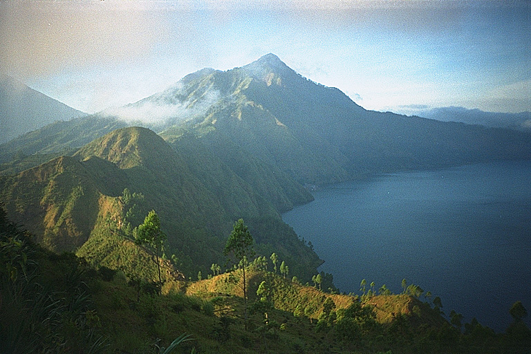
Within minutes, I was on the top of the rim.
It was trivial.
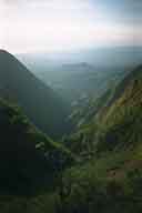
(This picture was taken later in the morning after I had come down.
From the parking lot you can see how far it is up to the top of the rim.
If you can walk uphill, you can do it.)
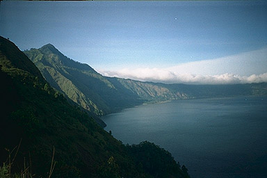
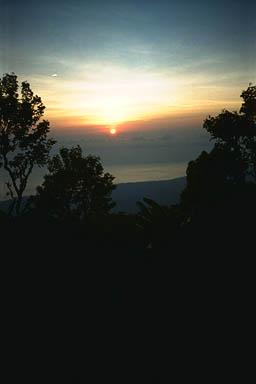 It was already getting light, and my timing was perfect.
I was on the eastern side of the rim on the eastern side of the island.
The sun was just starting to peek out .
It was already getting light, and my timing was perfect.
I was on the eastern side of the rim on the eastern side of the island.
The sun was just starting to peek out .
I took some of the most spectacular pictures when I was up there.
There were no other tourists. None.
Click on these two pictures below for larger images.
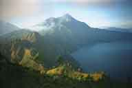
 I took a hike up toward Mt Abang. I thought at the time
I could go there and climb it, but it was too far and I was
having a good enough time just hanging out doing what I was doing.
But you can see how close it is - certainly doable.
I took a hike up toward Mt Abang. I thought at the time
I could go there and climb it, but it was too far and I was
having a good enough time just hanging out doing what I was doing.
But you can see how close it is - certainly doable.
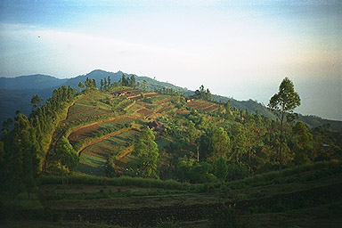 There were farmers up there, though.
These people woke up every day farming these fields.
There were farmers up there, though.
These people woke up every day farming these fields.
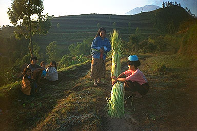 Many of these people asked for money after I took their picture.
Even people who looked wealthy enough for clean clothes.
Here this woman prepares to carry stuff on her head;
note the curled up cloth she's wearing as a cushion.
Many of these people asked for money after I took their picture.
Even people who looked wealthy enough for clean clothes.
Here this woman prepares to carry stuff on her head;
note the curled up cloth she's wearing as a cushion.